Tens of thousands of active satellites are currently streaking through low Earth orbit, monitoring crops, guiding logistics fleets, and broadcasting telecommunications to the most remote corners of the globe. But as operational populations swell, an existential threat looms overhead. A collision with a debris fragment as small as 1 cm can instantly render a multi-million-dollar asset inoperable.
If the impact occurs at hyper-velocity, the targeted satellite risks fragmenting into thousands of additional high-speed projectiles. Each newly generated shard introduces further collision cross-sections to adjacent orbital planes, creating a runaway feedback loop that could render critical altitudes entirely unusable for generations.
Satellites in Orbit and the Limits of Manual Tracking
This operational bottleneck is shifting from a theoretical hazard to an immediate logistical strain. Orbital analyst Hugh Lewis recently published a detailed breakdown of Starlink’s semi-annual tracking metrics, revealing that SpaceX executed over 144,000 avoidance burns within a single six-month window—nearly double its previous operational rate.
The data exposes a critical trendline: as low Earth orbit populates, the annual collision-avoidance maneuver rate scales exponentially. The chart below plots these annual burns against the average number of active orbital platforms, demonstrating a tight exponential curve fitting ($R^2 = 0.9772$).
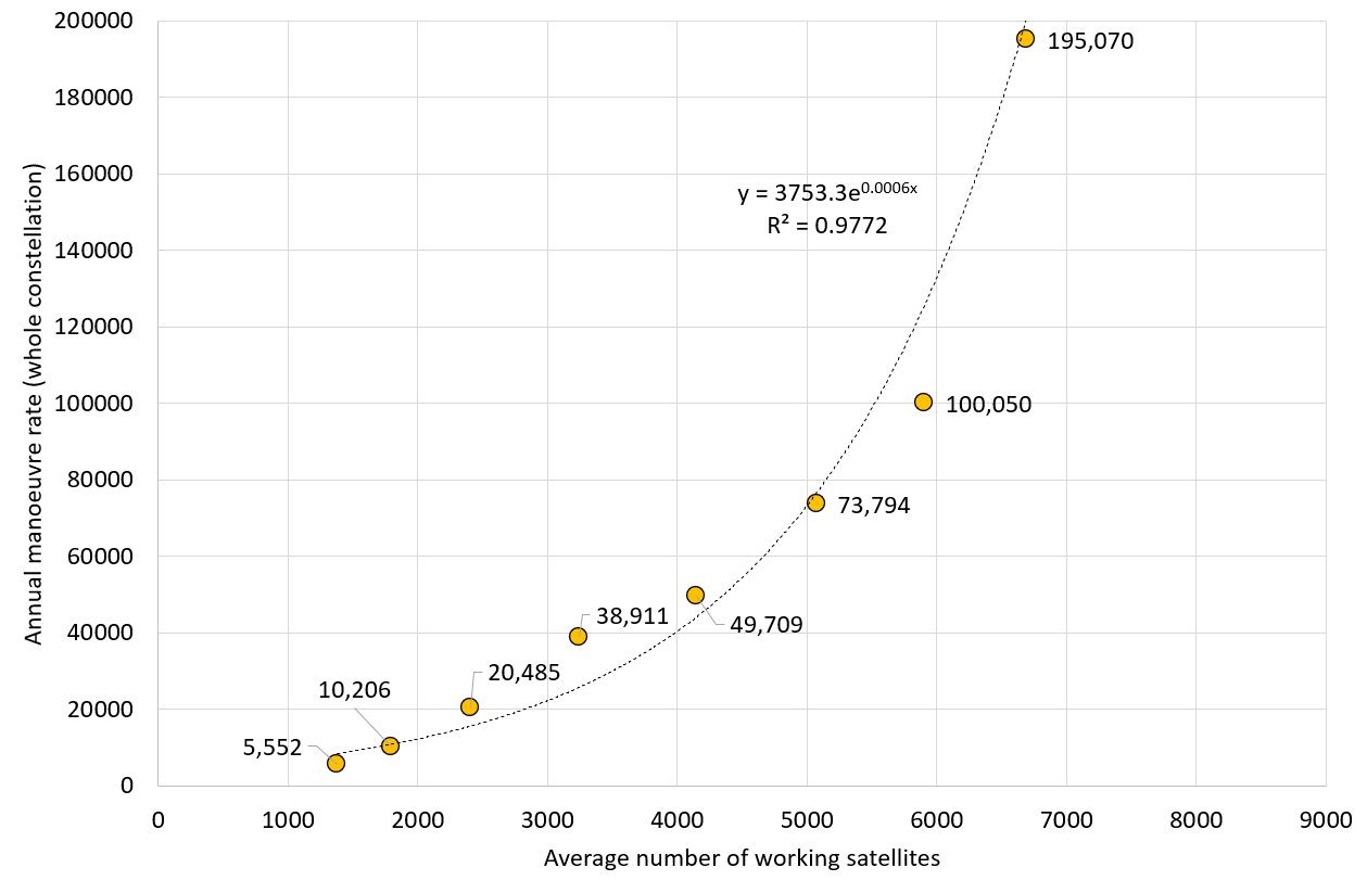
This trajectory serves as a stark warning that traditional ground-based, human-in-the-loop coordination mechanisms are rapidly approaching their physical constraints. Even when accounting for internal adjustments to probability warning thresholds, the exponential nature of this curve proves that every additional thousand satellites deployed introduces a disproportionate operational burden, threatening to completely overwhelm traditional ground operations.
Starlink as a Proxy for Global Traffic Dynamics
Starlink serves as an ideal case study because SpaceX remains the only massive constellation operator publishing consistent, multi-year empirical metrics detailing maneuver volumes. Because the vast majority of commercial operators maintain strict confidentiality surrounding their close-approach telemetry, Starlink’s data sheets stand as the industry’s best proxy for the true operational friction facing the modern space economy.
As sovereign fleets and untracked debris clouds multiply, ground-centric space situational awareness (SSA) frameworks will inevitably buckle under the analytical load. Relying entirely on down-linked radar tracking data and manual human sign-offs introduces structural inefficiencies at every stage of the lifecycle:
- Latency in Detection and Response: Shuttling radar telemetry from ground stations to centralized processing hubs, calculating conjunction data messages (CDMs), and waiting for manual commands to upload introduces critical propagation delays during fast-approaching conjunction windows.
- Ballooning Alert Volumes: As sensor thresholds tighten, operators are being flooded with thousands of low-probability alerts every week, leading to systematic alarm fatigue and increasing the risk of missing a catastrophic tracking event.
- Compounding Positional Uncertainty: Tracking objects from Earth introduces wide error ellipsoids. Without real-time, localized measurements, operators are frequently forced to burn fuel to avoid “ghost” risks that may actually clear the asset safely.
- Fragmented Tracking Data: Public tracking catalogs regularly conflict with private owner-operator telemetry, forcing companies to adjudicate space traffic coordinates using incomplete, desynchronized datasets.
- Coordination Overhead: When two active satellites from competing operators face a close approach, resolving which asset should maneuver—and in which direction—requires manual, cross-company communications that are highly unscalable.
- Fuel and Lifetime Trade-offs: Every defensive burn consumes valuable propellant, directly shortening the commercial mission lifecycle of the spacecraft and harming long-term project ROI.
- Extreme Relative Velocities: Conjunction events in LEO frequently occur at orbital intercept speeds exceeding 10 km/s. At these velocities, the window to detect, verify, and execute a survival burn narrows to mere minutes.
When an underlying infrastructure problem scales exponentially, any operational solution that scales linearly—or relies on manual human decision-making—is structurally guaranteed to collapse under its own weight. Space traffic requires a collision-avoidance methodology that scales natively alongside the threat profile. Pushing sensing, orbit determination, and maneuver execution directly onboard the spacecraft is the only mathematically viable path to outpace the coming wave of orbital congestion.
The Aviation Precedent: How TCAS Solved the Commons Problem
An autonomous, peer-to-peer tracking matrix sounds exceptionally difficult to coordinate without a centralized traffic cop. Yet, every day, between 12,000 and 14,000 commercial aircraft safely cross global corridors simultaneously. They achieve near-perfect safety records despite being built by competing international manufacturers, operated by crews speaking different languages, and guided by fragmented regional air traffic control sectors.
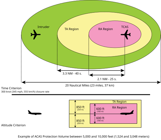
The core of this safety architecture is an onboard, peer-to-peer safety layer: the Traffic Collision Avoidance System (TCAS). Operating entirely independently of ground-based radar control, TCAS transponders continuously interrogate the surrounding airspace via radio frequencies. By calculating the precise time-of-flight of reciprocal transponder signals, the system builds an localized, real-time 3D map of proximal air traffic.
If an adjacent aircraft breaches a predefined safety bubble, TCAS alerts the flight crew. If the conflict worsens, the computers on board the two opposing aircraft automatically communicate to resolve the hazard, issuing coordinated “Resolution Advisories” (e.g., instructing one pilot to climb and the other to descend) without requiring ground-control intervention.
This level of structural safety was not adopted voluntarily. Early commercial aviation was significantly more dangerous, relying heavily on “see-and-avoid” visual procedures. The push for automated, peer-to-peer safety systems was catalyzed by the catastrophic 1956 Grand Canyon mid-air collision, where two passenger airliners struck each other in perfect weather conditions, prompting the creation of the Federal Aviation Administration (FAA).
Subsequent mid-air disasters throughout the mid-to-late 20th century repeatedly proved that visual tracking and intermittent ground-radar updates could not safely manage dense traffic environments. In response, regulators mandated TCAS for all commercial airframes, cementing automated, decentralized safety as a non-negotiable requirement of modern flight.
Why Space Has Not Adopted a Universal Transponder
Despite low Earth orbit experiencing an identical congestion crisis, translating a TCAS-style solution to satellite operations faces three significant institutional hurdles:
- Absence of a Universal Beacon: Satellite operations currently rely on a highly fragmented patchwork of military radar networks, commercial optical telescopes, and proprietary telemetry streams. Without a globally standardized “space traffic transponder,” spacecraft cannot actively broadcast or listen for real-time localized positions.
- Extreme Physical Constraints: Orbital dynamics require maneuver planning to occur hours or days before an event due to the high-velocity nature of LEO tracking. Integrating high-fidelity tracking sensors and shielded processing units into small-form-factor satellites strains tight mass, power, and thermal budgets.
- Fragmented Regulatory Authority: While aviation benefits from centralized international bodies like the ICAO and the FAA to enforce global compliance, space governance remains deeply balkanized. Dozens of sovereign space agencies, military commands, and commercial actors guard their proprietary tracking data, slowing the adoption of automated thruster control.
Engineering a Path to Orbital Autonomy
Despite these roadblocks, implementing a decentralized tracking loop is technically feasible using current satellite subsystems. The vast majority of modern spacecraft already carry integrated telecommand-and-telemetry antenna arrays. By overlaying a lightweight, low-power beacon protocol onto these existing radio links, adjacent satellites could actively exchange basic state vectors and coordinate avoidance paths directly.
Furthermore, modern avionics can now package energy-efficient microprocessing units alongside miniature laser or radar rangefinders within micro-satellite structures without drawing excessive current. By throttling computing power exclusively during high-risk orbital intersections and utilizing passive thermal cooling loops, these systems can compute real-time relative trajectories on the fly. This brings localized, autonomous situational awareness well within the reach of standard small-satellite architectures.
The primary hurdle remains standardisation. Despite the industry’s fondness for claiming compliance with data-sharing frameworks like the CCSDS, practical radio frequency engineering reveals that hardware realities frequently deviate from theoretical design sheets, making interoperability incredibly difficult to secure out of the box.
Because space lacks a singular global authority to mandate a universal traffic beacon, implementation must leverage existing market entry gates. Because nearly every major commercial space program depends directly on Western sovereign export approvals, launch site access, or institutional procurement contracts, regulators hold immense leverage.
By making the integration of an open-standard “Space Traffic Transponder” a mandatory prerequisite for receiving a commercial launch license or an export approval, the international community can effectively drive universal adoption from the top down—mirroring how the FAA originally integrated transponders into commercial aviation.
A Grave Warning for the Orbital Commons
In aviation, safety regulations were written in blood. Every automated system, from black boxes to TCAS, was forged from the direct investigation of fatal accidents that galvanized public opinion and forced immediate political action.
In orbit, because there are no human lives aboard uncrewed platforms to capture the public imagination, a catastrophic debris cascade will not command the same immediate political urgency. If the space sector fails to adopt that same life-or-death regulatory mindset—refusing to implement compulsory, onboard collision-avoidance standards—we risk condemning the orbital commons to an environmental crisis from which it may never recover.
NebuLink is a space market intelligence firm specializing in downstream application mapping, competitive tracking, and strategic space sector industrial reporting. For targeted market analysis or program evaluation, reach out at: Alistair@NebuLink.co.uk